
Featured News Items:
2025
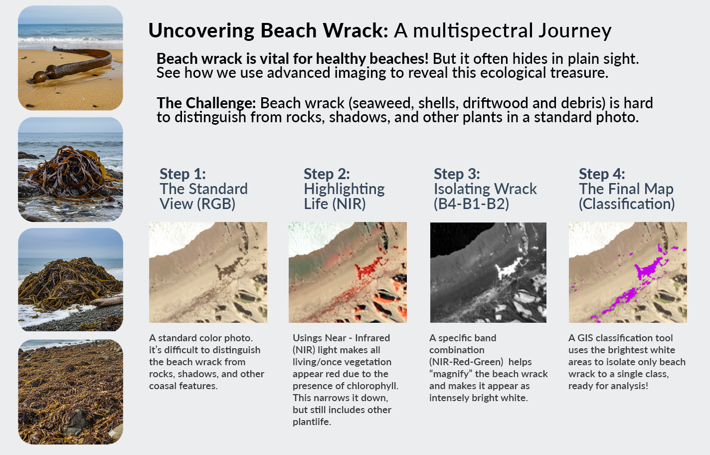
Ocean Imaging has been mapping Giant Kelp surrounding San Nicolas Island off the coast of California for over 15 years. Last year we began a multi-year project to not only map kelp, but also the beach wrack covering the island’s sandy beaches and rocky shoreline. What is beach wrack, you ask? Wrack can come in many forms from Giant Kelp and other seaweeds such as sargassum that washes ashore, to most any type of organic material that finds its way onto beaches. While sometimes seen as unsightly and you might avoid it when strolling along the sand, wrack is a critical part of the coastal ecosystem and provides a variety of essential ecological services.
For example, Beach wrack is a primary source of nutrients for the beach ecosystem. When it decomposes, it releases nutrients that are used by both terrestrial and marine organisms. It forms the base of the food chain by providing food and shelter for a variety of invertebrates like beach hoppers, kelp flies, and beetles. These small creatures, in turn, become a vital food source for shorebirds, migratory birds, and even some land animals. Wrack also provides nesting habitat for some birds and a safe place for sea turtle hatchlings to take cover as they make their way to the ocean.
Beach wrack essentially provides the ecological link between land and sea. It acts as a bridge, transferring nutrients and energy from the marine environment to the terrestrial environment. Since the sandy beach itself has little to no primary production, it is highly dependent on this imported material to support its unique ecosystem. This constant flux of organic matter ensures the health and biodiversity of both the beach and nearshore environments.
In addition, beach wrack plays a critical role in coastal geomorphology. It acts as a natural barrier that helps to reduce wave energy and protect the shoreline from erosion. The organic material and its associated fauna can trap windblown sand, which over time contributes to the formation and stabilization of coastal dunes. These dunes are essential for protecting coastal properties from storm surges and rising sea levels.
This is why it is important to keep tabs on this constantly changing mini ecosystem, which Ocean Imaging is proud to be a part of! So, the next time you are walking on the beach, maybe take a closer look at the organic debris piled on the sand. We are!
Ocean Imaging maps drinking water availability of federally endangered Florida Key Deer
.jpg) In 2016 Jan Svejkovsky, founder and President of Ocean Imaging, relocated with his wife from San Diego to the Florida Keys. Lifelong wildlife enthusiasts and long-time wildlife rehabbers in California, they founded “Save Our Key Deer” (SOKD – www.saveourkeydeer.org ), a non-profit 501-C corporation advocating for the endangered Florida Key Deer that survive only on a portion of the Keys. One of SOKD’s multiple activities is scientific research, financed by the group. Following the devastating Hurricane Irma in 2017, Svejkovsky utilized OI technical staff’s expertise to quantify vegetation damage in the Key Deer habitat and subsequent recovery rates using high resolution satellite imagery. The study was published in the journal “Estuaries and Coasts”.
In 2016 Jan Svejkovsky, founder and President of Ocean Imaging, relocated with his wife from San Diego to the Florida Keys. Lifelong wildlife enthusiasts and long-time wildlife rehabbers in California, they founded “Save Our Key Deer” (SOKD – www.saveourkeydeer.org ), a non-profit 501-C corporation advocating for the endangered Florida Key Deer that survive only on a portion of the Keys. One of SOKD’s multiple activities is scientific research, financed by the group. Following the devastating Hurricane Irma in 2017, Svejkovsky utilized OI technical staff’s expertise to quantify vegetation damage in the Key Deer habitat and subsequent recovery rates using high resolution satellite imagery. The study was published in the journal “Estuaries and Coasts”.
More recently, Svejkovsky and OI processed and published results of a multi-year field study done with the aid of SOKD volunteers monitoring the seasonal availability of natural and anthropogenic drinking water sources available to the deer. The results revealed that in many parts of their still existing habitat the Key Deer are now fully dependant on human sources of drinking water, a situation only expected to worsen with increasing sea level rise and climate change. This has major implications for future management and the deer’s survival. The study was published in the “Journal for Nature Conservation” and the paper is available by clicking on the above image.
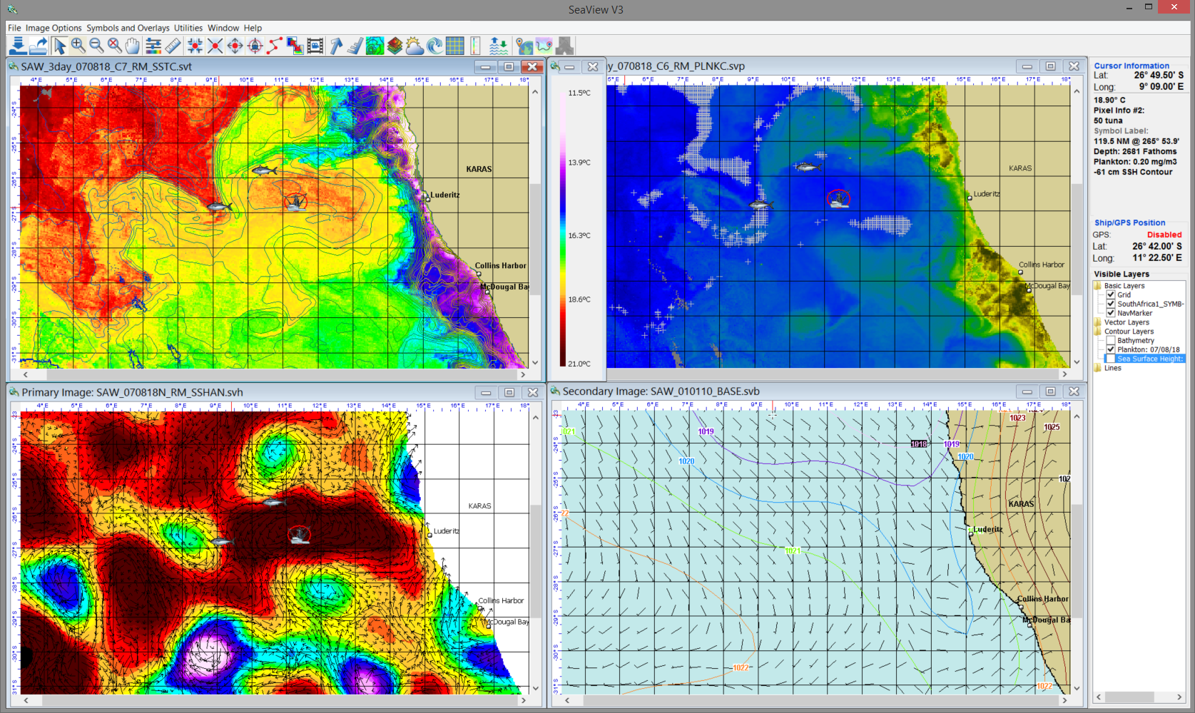
2024 - Ocean Imaging & SeaView Fishing Celebrate 40 Years of Providing Satellite-Derived Ocean Analyses for Fisheries Support
July 2023 – Ocean Imaging Renews Long-Term Contract with the City of San Diego to Help Monitor Coastal Water Quality
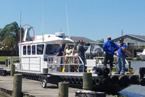
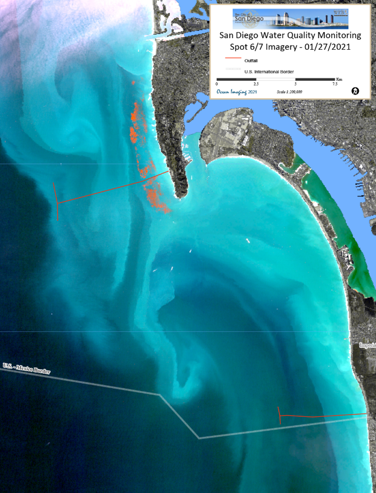 Since 2002 Ocean Imaging (OI) has partnered with the City of San Diego’s Public Utilities Department and the United Stated International Boundary and Water Commission to utilize satellite and aerial imagery to better understand regional water quality conditions off San Diego California. OI pioneered the utility of satellite and aerial remote sensing for detection of polluted coastal runoff and sewage outfall effluent plumes in the mid-’90s as part of coastal applications development work funded by NASA’s Commercial Remote Sensing Program. That research led to several demonstration studies with promising results. The EPA and California state agencies took notice of OI’s work and in 2002 a remote sensing-based monitoring component was formally added to two sewage discharger permits in the San Diego-Tijuana, Mexico region. Successes in the project’s first year resulted in the project’s extension, and now 21 years later the City has contracted with OI for another five years. The project is presently focused on detecting and tracking the dispersion of wastewater plumes from local ocean outfalls and nearshore sediment plumes caused by stormwater runoff or outflows from local bays and rivers such as the Tijuana River just south of the U.S.–Mexican border. OI will also build a state-of-the art dashboard-style, interactive website that facilitates increased and more efficient analysis of the remotely-sensed data by the City’s researchers and constituents. Take a look at this video for more information: https://www.sandiego.gov/public-utilities/sustainability/ocean-monitoring/reports/ocean-imaging-report-archives.
2022-2023 - OCEAN IMAGING Works With Oregon Department of Fish and Wildlife to Map Coastal Kelp Beds
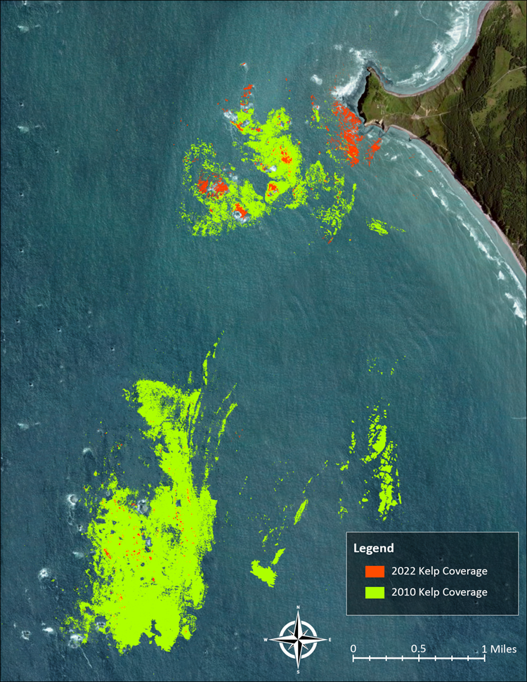 As has been emphasized in previous OI News stories, Giant Kelp (Macrocystis pyrifera) and Bull Kelp (Nereocystis) forests along the west coast of North America and around the world are a valuable resource and provide a critical habitat and nursery grounds to hundreds of marine species such as seals, sea urchins, abalone, sea otters, octopuses, numerous fish species and even whales. These underwater ecosystems are well known for their rich biodiversity and carbon storing capacity. These large brown algae can grow up to a foot a day but can also be nearly wiped out by a single storm. Over the past several years the health of kelp beds along the Oregon Coast has been highly variable with beds in some areas showing extreme decline. In areas such as the waters off Port Orford and Cape Blanco that were once robust, thriving kelp forests are now virtually barren due to exploding populations of purple sea urchins which will graze the kelp beds down to almost nothing. Ocean Imaging (OI) has been mapping kelp around the world since the late 1990s.
Read More →
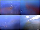
NOVEMBER 2021 - OCEAN IMAGING COMPLETES STUDY TO IMPROVE OIL DETECTION CAPABILITY USING A PROTABLE, UAS-BASED SCAT RECONNAISSANCE SYSTEM
.png) In 2019 Ocean Imaging was awarded funding for a two-year project to develop Small Unmanned Aircraft Systems (sUAS) designed to help detect and map oil in coastal and inland zones. Shoreline Cleanup Assessment Technique (SCAT) operations are a fundamental part of oil spill response for both marine and inland spills. The project funded by California Department of Fish and Wildlife (CDFW) Oil Spill Prevention and Response (OSPR) division aimed to incorporate more sophisticated sensors into a portable sUAS to assess the efficacy of the enhanced equipment and novel oil detection algorithms designed to help responders and SCAT teams more quickly and accurately identify and assess oiled areas in shoreline and inland waterway habitats.
In 2019 Ocean Imaging was awarded funding for a two-year project to develop Small Unmanned Aircraft Systems (sUAS) designed to help detect and map oil in coastal and inland zones. Shoreline Cleanup Assessment Technique (SCAT) operations are a fundamental part of oil spill response for both marine and inland spills. The project funded by California Department of Fish and Wildlife (CDFW) Oil Spill Prevention and Response (OSPR) division aimed to incorporate more sophisticated sensors into a portable sUAS to assess the efficacy of the enhanced equipment and novel oil detection algorithms designed to help responders and SCAT teams more quickly and accurately identify and assess oiled areas in shoreline and inland waterway habitats.
The system was built using CDFW’s exiting sUAS platform and multispectral camera adding two additional cameras imaging in the ultraviolet and thermal infrared wavelengths. Custom software was written to facilitate the incorporation of these sensors and processing of the resulting data. Ultimately two study locations in California (the McKittrick natural oil seeps and a natural seep oiled beach below Carpinteria Bluffs in California) were chosen that offered fresh and weathered oil targets needed for the creation of an oil detection and classification algorithm. A multistep image processing algorithm was developed using the new sensor bands that effectively classified high probability oil targets with minimal false positive identifications. The results of the study showed that a sUAS equipped with a state of the art, 5-channel multispectral and thermal infrared imaging system could provide accurate and easy to interpret oil identification information to SCAT and other response workers at a reasonable cost.
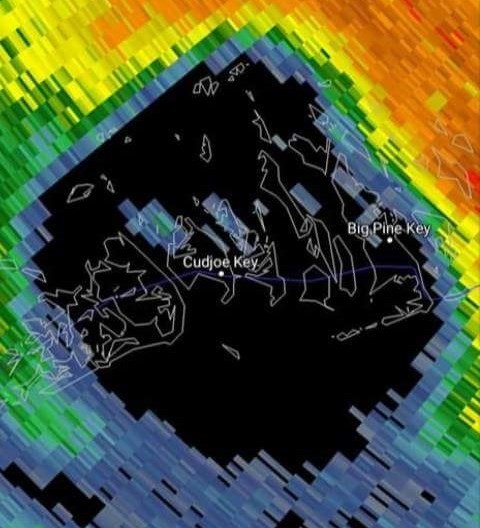
June 2020 - OCEAN IMAGING CONDUCTS GIS STUDY OF VEHICLE-CAUSED KEY DEER DEATHS IN THE FLORIDA KEYS
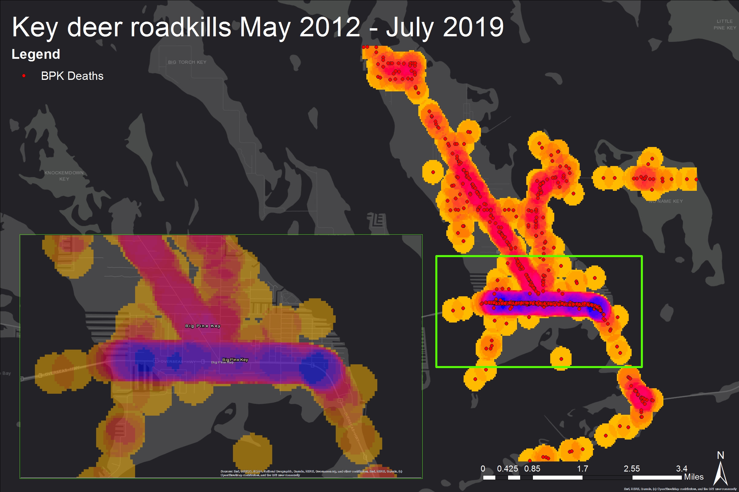 The Lower Florida Keys are the unique home to the Key deer (Odocoileus virginianus clavium), a subspecies of the whitetail deer and federally listed as an endangered species. Saved from extinction in the 1950s, the deer have rebounded from a mere 25-50 individuals in 1950, to 700-800 today. Affected by major habitat losses in the past decades, as well as recent mass casualties during a screwworm epidemic in 2016 and Hurricane Irma in 2017, their most persistent cause of death is a collision with a motor vehicle. Each year 100+ Key deer (i.e. 9-15% of the entire world population) die that way.
There are plentiful road signs alerting motorists to the presence of deer on Big Pine and No Name Keys – the two islands holding the majority of the Key deer population. Smaller sub-herds also live on neighboring islands to the west, however, where no signage has historically existed, and most tourists and even many residents are unaware of the possibility of a collision with a deer. Ocean Imaging’s President, Dr. Jan Svejkovsky, lives in the Keys and with his wife runs the non-profit organization “Save Our Key Deer” (SOKD). For the past 2 years SOKD has been lobbying the Florida Dept. of Transportation (FDOT) to install deer-warning signs on all islands with Key deer herds, in hopes that the raised awareness may reduce the number of collisions and deer deaths. In late 2019 FDOT agreed to the signage additions. The question then was where to locate the signs for best effect?
SOKD obtained detailed vehicle-caused deer death location records from the US Fish & Wildlife Service and the Monroe County Sherriff’s Office for the past 8 years,
and Ocean Imaging technicians used GIS analysis software to create maps of collision “hot spots”. The hot spots indicate where the deer cross the road most frequently which, in turn, tends to correlate with natural resources (e.g. a drinking water source) or human-related ones (e.g dumpsters behind a restaurant where deer tend to look for food scraps). The hot spot results were forwarded to FDOT by SOKD and are being used to plan out the new sign locations to be installed later this year or in early 2021.
Select Publications
SeaTechnology: "Adding a Multispectral Aerial System to the Oil Spill Response Arsenal"
More →
OI News Items
2025:
Ocean Imaging has been mapping Giant Kelp surrounding San Nicolas Island off the coast of California for over 15 years. Last year we began a multi-year project to not only map kelp, but also the beach wrack covering the island’s sandy beaches and rocky shoreline.
Ocean Imaging's latest peer-reviewed scientific paper on the existing unavailability of natural drinking water sites as a prime factor driving the domestication of Key deer.
2024:
Ocean Imaging & SeaView Fishing Celebrate 40 Years of Providing Satellite-Derived Ocean Analyses for Fisheries Support
April 2023:
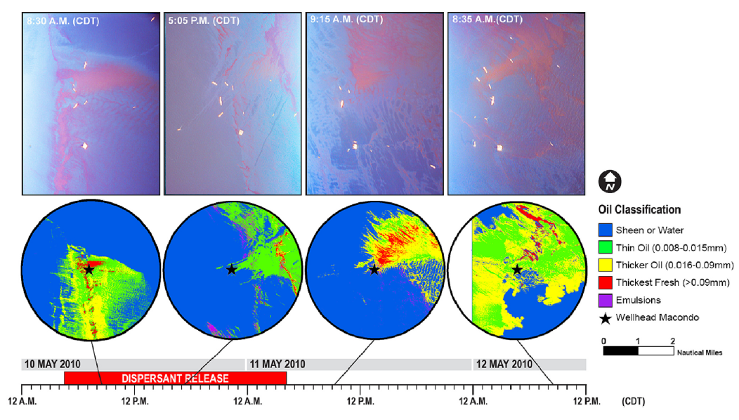 Ocean Imaging's latest peer-reviewed scientific paper on the use of remote sensing to study the effects of sub-sea dispersants during the Deepwater Horizon oil spill
March 2023:
 SeaView Fishing Mobile app now available for Apple Mobile Devices.
october 2021:
 Ocean Imaging rolls out SeaView Mobile app
JUNE 2021:
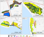
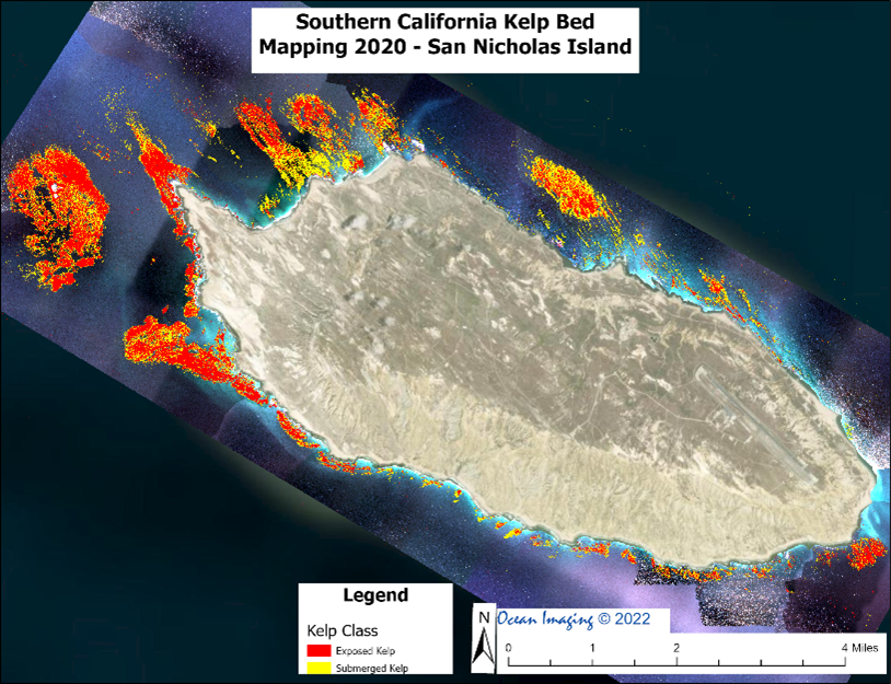 Ocean Imaging Completes Latest Round of Projects to Map Kelp Off the Coast of California
January 2020:
 Ocean Imaging publishes peer-reviewed results of post-hurricane Irma study in the Florida Keys
January 2019:
 Ocean Imaging receives funding to improve oil detection capability using a portable UAS-based SCAT reconnaissance system
December 2018:
 Ocean Imaging Celebrates 35 Years of "Finding Fish from Space"
December 2018:
 Ocean Imaging Marks 15 Years of an Environmental Monitoring Project to Help Restore California's Wetlands
27 November 2018:
 Ocean Imaging Completes Study of Vegetation Response to Hurricane Irma in the Florida Keys
April 2018:
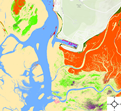 Ocean Imaging Continues 15 Years of Work to Map Eel Grass in Morro Bay, California
25 April 2017:
 OI and MSRC Partner to Equip All TRACS Aircraft with State-of-the-Art Air-to-Ground Data Transfer Systems
2016-2017:
 OI and MSRC Adapt OI's TRACS for Deployment on Helicopters
4 November 2016:
 Ocean Imaging's lastest peer-reviewed scientific paper on the characterization of oil spills during the Deep Water Horizon Oil Spill
22 JUly 2016:
 NOAA Partners with OI to Advance Oil Spill Remote Sensing
News/Publications/archives →