
Image Data Acquisition
 Tactical Response Airborne Classification System (TRACS)
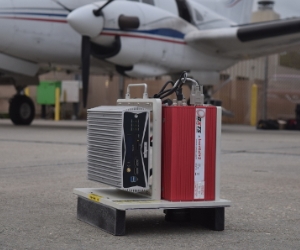
The TRACS system is the second-generation aerial mapping system designed for oil spill mapping and response, yet ready for use in many different applied remote sensing applications such as fire mapping, habitat mapping and animal surveys. TRACS is a portable, single-unit-design system, integrating a 3-CCD, multispectral RGB digital camera with a thermal infrared imaging camera and a high accuracy GPS-Inertial Measurement Unit (IMU). The cameras are equipped with special wide-angle lenses to increase the imaging swath width partnered with specially developed acquisition and processing software to both correct for lens distortion and automatically georeference each image frame to provide highly accurate geospatial data. The system provides 12-bit imagery at 20cm – 4m spatial resolution. Being compact and portable the system is ready-made to be flown on most any aircraft of opportunity and can be utilized for both Common Operating Picture (COP) and tactical use. Ocean Imaging owns multiple TRACS units staged in coastal cities of the U.S. Three of which are operated by the Marine Spill Response Corporation (MSRC). Some specific advantages of this aerial system are:
 Portability:
Entire system measures approximately 13x12x15 inches, weighs less than 27 lbs. and is controlled via a remote laptop interface. 24-28V DC or 115-220V AC power source can be derived either directly from the aircraft or from batteries (draw is <10Amps). TRACS is rugged and highly portable suited for research and operational mapping work in a variety of aircraft from fixed wing to rotary aircraft.
12-Bit Radiometric Resolution:
Allows very broad brightness range for diverse substrate conditions with extremely high signal-to-noise ratio. The state-of-the-art thermal camera integrated into the system provides 1024x768 image frame size in a spectral range of 7.5um – 14um with a thermal resolution of <50 mK and accuracy of 1.5K.
Customizable Spatial Resolution:
The TRACS can be flown at any altitude above approximately 1,000’, resulting in spatial data resolutions of 20cm to 4+m. Successful data acquisitions are possible under clouds, thus lessening the dependence on clear weather. Wide-angle lenses paired with custom geo-correction software increase the instantaneous imaging swath to provide more efficient target mapping.
Custom In-flight Software:
The TRACS Acquisition and TRACS Processing custom software applications provide a user-friendly interface and powerful flexibility giving TRACS the capability to be used as a fast and efficient tactical tool as well as an accurate scientific instrument. Onboard image mosaicking capability combined with OI-MSRC’s proprietary air-to-ground data communication system allows the operator to transmit geospatially accurate image mosaics down to a ground station or response vessel within minutes of data acquisition.